What the app shows you
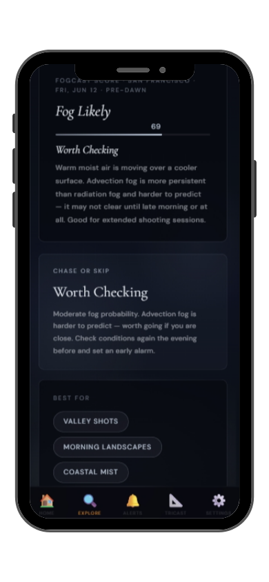

Full FogCast score, fog type, chase-or-skip verdict, and 10-day outlook — all in the app.
Get LightCast Suite on iOS
Know before you drive: FogCast checks the conditions that produce photogenic fog
Get more than a snapshot of current conditions. The LightCast app unlocks everything to plan ahead
Humidity alone isn't enough. Wind alone isn't enough. Cloud cover alone isn't enough. Photogenic valley fog requires several conditions to line up at once, and most weather apps don't read them together.
Set a FogCast threshold once. The app will alert you when conditions at your saved locations look promising, so you're not manually checking at 4am.

Don't waste a sunrise drive. Check FogCast before you leave.
Download on the App StoreLauterbrunnen is a glacially carved valley in the Bernese Oberland of Switzerland — a sheer-walled U-shaped canyon 300 meters deep and less than a kilometer wide, with 72 waterfalls dropping from the clifftops and a village on the flat valley floor. The geometry of the valley makes it one of the best radiation fog traps in the Alps: cold air pools on the flat floor between the vertical walls overnight, producing dense fog that fills the canyon while the Eiger, Mönch, and Jungfrau above remain clear.
The view from Grütschalp or the lower Männlichen ridge across the fog-filled Lauterbrunnen valley toward the Jungfrau massif is one of the classic Swiss alpine fog shots. When the valley is completely white below and the 4,000-meter peaks are lit by alpenglow above, the vertical relief is almost overwhelming. The village and waterfalls disappear in the fog while Staubbach Falls — dropping 297 meters from the clifftop — sometimes emerges ghostly above the cloud layer. Late autumn, October through December, is the most reliable fog season.
Valley fog at Lauterbrunnen forms on calm, clear nights when the narrow canyon geometry prevents any air circulation and cold pooling is intense. Check dew point the evening before: if the valley floor temperature approaches the dew point by midnight with calm winds, dense fog is very likely by pre-dawn. Positions above the valley rim on the Kleine Scheidegg or Grindelwald sides give the best above-fog views.