iOS App Exclusive

Fog Probability Forecast for Photographers
Standard weather apps don't predict morning fog. FogCast does. It reads six atmospheric variables overnight and scores fog probability, likely type, formation timing, and burn-off window
Try FogCast in the iOS App
7-day free trial · then $2.99/mo
How it works
Six Variables. One Probability Score.
Fog formation is more predictable than most photographers realize — the problem is the data that matters isn't surfaced by standard weather apps. FogCast pulls six variables from the overnight forecast and weights them the way meteorologists do, not the way a generic weather score would. The result is a number you can act on: set the alarm or don't.
Dew Point Depression
The gap between air temperature and dew point. Below 2°C means the air is near saturation — fog is very likely. This single variable carries the most weight in the score.
Relative Humidity
Above 95% indicates near-saturated air at the surface. Below 80% and most other variables can't overcome the dryness.
Wind Speed
Fog needs calm air to form and hold. Under 5 mph is ideal. Above 15 mph, fog disperses before it can pool in low terrain.
Overnight Sky Clarity
Counterintuitive: clear skies produce the best radiation fog. Clear overnight skies allow rapid ground cooling, pushing surface temperature toward the dew point. Overcast nights trap heat and suppress fog.
Temperature Trend
If overnight temperature is converging toward the dew point hour by hour, fog probability increases significantly. FogCast reads the overnight temperature arc to catch this pattern.
Current Visibility
Direct confirmation of fog presence. Below 1 km is dense fog, 1–5 km is moderate mist. Used to confirm the score when fog is already forming.
Score guide
What the Number Means
85–100
Fog confirmed or near-certain. Conditions are fully aligned. Be in position before sunrise.
65–84
Likely. Most variables are aligned. Fog will probably form in low terrain. Worth getting up for.
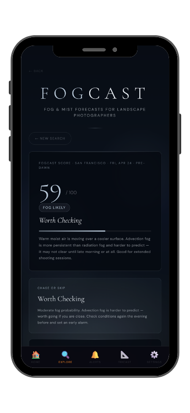
35–64
Possible. Conditions are partially aligned. Patchy mist or light fog is plausible, particularly in valleys.
0–34
Unlikely. One or more key variables are missing. A clear morning, not a foggy one.
Fog types
FogCast Identifies What Kind of Fog to Expect
The type of fog affects how long it lasts, where it pools, and how it looks. FogCast identifies the most likely type based on your location's elevation, wind, and atmospheric conditions.
🌄
Radiation Fog
Forms on calm, clear nights as the ground cools rapidly and surface air reaches the dew point. Typically clears within 1–2 hours of sunrise. Plan to be in position before dawn — it can disappear fast.
🏔️
Valley Fog
Cold air drains into low terrain and pools in basins. Produces the layered, sea-of-mist shots with hilltops emerging above the cloud. Can be denser and more persistent than radiation fog. Find elevation above the fog layer for the best compositions.
🌊
Advection Fog
Forms when warm moist air moves over a cooler surface — common near coastlines and large water bodies. More persistent and harder to predict than radiation fog. May not clear until afternoon or at all.
🔔
Get the alert the night before
Save your locations in the app and set your threshold. FogCast sends a push notification when tomorrow morning's fog probability is high — so you can decide whether to set the 4am alarm before you go to sleep, not at 3:45am when it's already too late to plan.
Part of LightCast Suite
Every Condition Photographers Chase, in One App
FogCast is one of many tools in LightCast. The same app that sends you a fog alert can also score tonight's Milky Way visibility, tomorrow's golden hour quality, and whether the wind is too strong to fly your drone.
Common Questions
How do you predict fog for photography?
Check six variables together: dew point depression, relative humidity, overnight wind speed, sky clarity, temperature trend, and current visibility.
When dew point depression is below 2°C, humidity above 90%, wind under 5 mph, and skies are clear overnight — fog probability is high. FogCast automates this check and gives you a score with timing. Available in the
LightCast iOS app.
What time does fog form for photography?
Radiation fog typically forms 2 to 3 hours before sunrise, during the coldest part of the overnight window. The most photogenic phase is 30 minutes before sunrise through 60–90 minutes after, when the fog thins and catches early backlit sun. FogCast shows estimated formation time and burn-off window for your location.
What is the difference between radiation fog and valley fog?
Radiation fog forms when the ground cools rapidly on a calm, clear night and surface air reaches the dew point. It's shallow and typically clears within 1–2 hours of sunrise. Valley fog forms when cold air drains into low terrain and pools — it sits in layers and produces the classic sea-of-mist shots with hilltops above the cloud. Valley fog can persist through mid-morning.
What season is best for fog photography?
Autumn is the strongest season for most inland locations. Warm days evaporate moisture from the ground, cool nights condense it. Spring is second. Summer nights are usually too warm; winter often too dry for high-probability radiation fog setups.
Is FogCast free?
FogCast is exclusive to the
LightCast iOS app. The app includes a
7-day free trial, then $2.99/month. GoldCast, StarCast, and DroneCast are also available free on web at
lightcastsuite.com.