FogCast · Mount Mitchell, NC
Fog Forecast for Mount Mitchell
Know before you drive: FogCast checks the conditions that produce photogenic fog
Reading current conditions…
🔒 App Exclusive
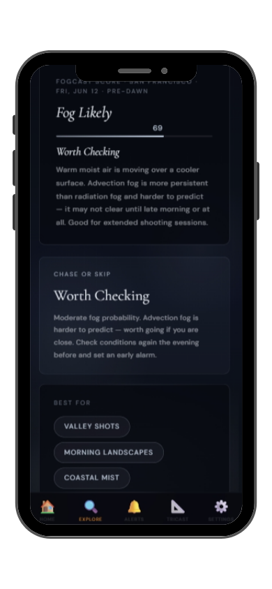
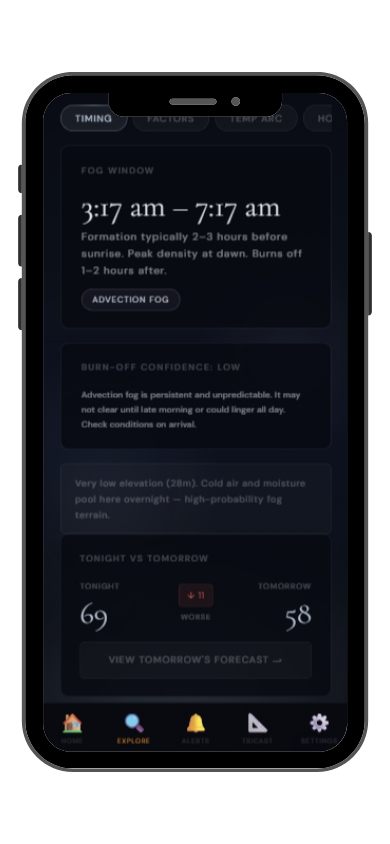
The full FogCast forecast is in the app.
Get more than a snapshot of current conditions. The LightCast app unlocks everything to plan ahead
- 📈 Full FogCast score (0–100)
- 📅 7-day fog outlook
- 🌅 Best photography windows
- 🔔 Push alerts when conditions improve
- ⭐ Save favorite locations
Download LightCast on iOS
7-day free trial · $2.99/mo
Why fog is hard to predict
Humidity alone isn't enough. Wind alone isn't enough. Cloud cover alone isn't enough. Photogenic valley fog requires several conditions to line up at once, and most weather apps don't read them together.
Dew Point Depression
When air temperature and dew point converge below 2°C, the air is near saturation. This is the single strongest fog predictor and the first thing FogCast checks.
Wind Speed
Fog needs calm air. Below 5 km/h is ideal. Above 15 km/h, fog disperses before it can pool in the valley. A standard weather app won't flag this combination.
Overnight Sky Clarity
Clear overnight skies let the ground cool rapidly, pushing surface temperatures toward the dew point. Counterintuitively, clouds overnight suppress radiation fog.
Temperature Trend
FogCast reads the overnight temperature arc. If temps are converging toward the dew point hour by hour, fog probability increases significantly by pre-dawn.
Check today's FogCast
What the app shows you
Full FogCast score, fog type, chase-or-skip verdict, and 10-day outlook — all in the app.
Get LightCast Suite on iOS
Get notified instead of checking every morning
Set a FogCast threshold once. The app will alert you when conditions at your saved locations look promising, so you're not manually checking at 4am.
⏰
Wake up only when conditions look promising
🚗
Avoid wasted drives when fog never forms
⭐
Save your favorite photography locations
🌫️
Never miss a rare dense fog event
Fog photography at Mount Mitchell
Mount Mitchell, at 2,037 meters the highest peak east of the Mississippi River, sits above the surrounding Blue Ridge ridgelines and is frequently in the clouds rather than below them. The summit and upper elevations are enshrouded in cloud and fog on over 200 days per year — the trees above 1,700 meters are stunted spruce and fir shaped by the persistent wind and moisture, giving the high ridge a subalpine character unusual for the eastern US. When mist moves through the Fraser fir forest near the summit, the ghostly moss-draped trees and limited visibility create a dramatically atmospheric scene.
The best fog photography on Mitchell is not inversion photography from above, but immersive fog within the high-elevation forest itself. The summit area, the Balsam Nature Trail, and the ridgeline toward Clingmans Peak are excellent when visibility drops to 30 to 100 meters and the forest becomes a series of silhouettes emerging from white. The Blue Ridge Parkway below Mitchell, particularly around milepost 355, offers valley-fog views when the lower elevations are filled with radiation fog and the upper ridges are clear.
Cloud immersion on Mount Mitchell is most frequent from October through March. Unlike valley fog, this cloud fog is driven by frontal systems and orographic lift rather than overnight cooling. When weather forecasts call for clouds and marginal visibility at summit elevation, photographic conditions in the high spruce-fir forest are often at their best.
Other fog photography locations
Frequently asked
Can I check FogCast on the website?
This page shows a preview of current conditions, including humidity, wind, temperature, and dew point. The full FogCast score, 7-day outlook, push notifications, and best shooting windows are available exclusively in the LightCast app for iOS.
Is FogCast free?
The current conditions preview on this page is free, no account needed. The full FogCast tool is in the LightCast Suite iOS app, which includes a 7-day free trial. After the trial it's $2.99/month, cancel anytime in the App Store.
Why use FogCast instead of checking humidity?
Humidity alone doesn't tell you whether photogenic fog is likely. High humidity with strong wind produces no fog at all. FogCast combines dew point depression, wind speed, overnight sky clarity, temperature trend, and visibility into a single score built specifically for fog photography planning.
What is FogCast's scoring scale?
FogCast scores fog conditions from 0 to 100. A score of 75 or above indicates dense fog is expected. 55 to 74 means fog is likely and worth chasing. 35 to 54 suggests patchy mist is possible. Below 35, conditions are unlikely to produce photogenic fog. The full score is available in the LightCast app.