LightCast · Illinois

Best Landscape Photography Locations in Illinois
Sunset, night sky, and drone — the top spots in Illinois, and how to know when conditions are right before you make the drive.
iOS app: $2.99/mo · 7-day free trial
🌅 Sunset & Golden Hour · Illinois
Best Sunset Locations
Illinois doesn't have mountains or coastline, but it has something underrated: enormous skies and flat terrain that lets you see color develop from horizon to horizon. Lake Michigan's western shore in Chicago gives you a true waterfront sunset facing west across the city skyline, and the southern tip of the state drops into the Shawnee Hills — canyon bluffs and forested ridges that feel nothing like the rest of the Midwest. Cloud structure is everything on the prairie — a partly cloudy evening with broken cumulus produces dramatic color over flat farmland that a clear sky never will. Check GoldCast before making the drive.
🌆
Chicago Lakefront — Montrose Beach & North Avenue Beach Lake Michigan · Cook County
Chicago's lakefront faces east, which makes it ideal for sunrise — but the city skyline at golden hour from Montrose Beach or North Avenue Beach looking south is one of the most distinctive urban landscape shots in the Midwest. The light at golden hour rakes across the skyline from the west and reflects off the lake surface in the foreground. Montrose Harbor adds boat masts and breakwater texture to the composition. In winter, ice formations along the shoreline create extraordinary foreground interest.
🪨
Garden of the Gods, Shawnee National Forest Saline County · Southern Illinois
Garden of the Gods is Illinois's most dramatic landscape — sandstone formations with names like Camel Rock and Anvil Rock rising above forested ridgelines in the Shawnee Hills. At sunset, the warm light catches the orange and tan sedimentary layers and the surrounding canopy turns gold in fall. The main overlook faces west-southwest, making it one of the few spots in the state purpose-built for evening light. October is peak season; arrive early — the parking area fills on fall weekends.
GoldCast
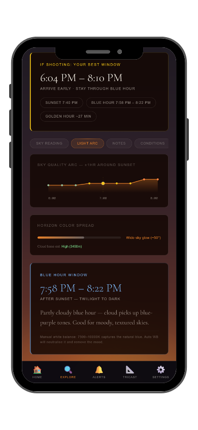
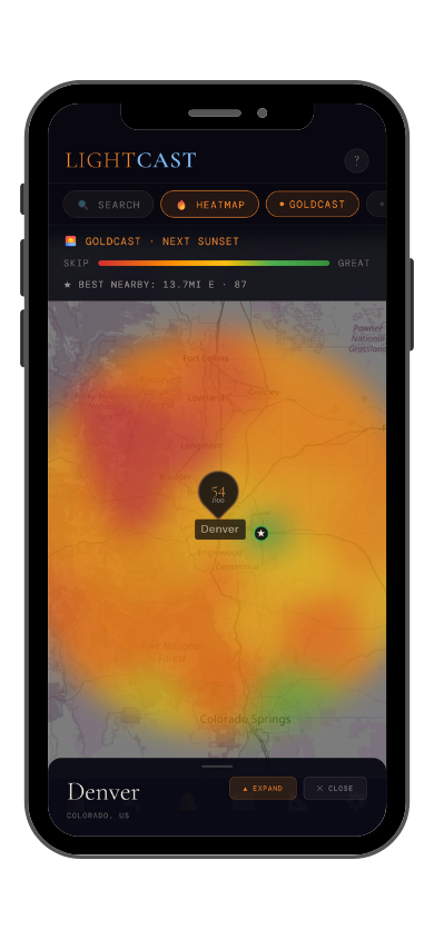
Golden hour timing + fog & cloud forecast
Sunset · Sunrise · Marine Layer · Cloud Cover
GoldCast shows exact golden hour and blue hour windows, plus cloud cover so you know whether the light will actually reach your subject. Check conditions for any Illinois location before you leave.
Get LightCast on iPhone
$2.99/mo · 7-day free trial
Check GoldCast on web →
GoldCast: golden hour forecast (left) · conditions heatmap (right)
🌌 Astrophotography · Illinois
Best Astrophotography Locations
Light pollution from Chicago, St. Louis, and the suburban corridor along I-55 covers a large portion of the state. The darkest skies are in the far southern tip, where the Shawnee National Forest sits well clear of major metro influence, and in pockets of the central agricultural belt where small towns are widely spaced. Transparency and humidity are the key variables in the Midwest — summer heat brings atmospheric moisture that scatters light even when skies appear clear. The best windows are cold, dry nights in late fall through early spring when the air is crisp and stable. Check StarCast before driving south.
🌲
Shawnee National Forest — Devil's Backbone & Cedar Lake Bortle 3–4
The southern tip of Illinois around the Shawnee National Forest offers the state's best night sky access. Devil's Backbone Park near Grand Tower sits on a bluff above the Mississippi River with open southern exposure and minimal local light interference. Cedar Lake to the east provides dark water reflection foregrounds. The Milky Way core is well-positioned from this latitude in summer, and the forested ridgelines of the Shawnee Hills add silhouette structure to compositions. The nearest significant metro light dome — St. Louis — sits far enough west to be manageable.
🔭
Ryerson Conservation Area, Riverwoods Bortle 6
Not a dark sky destination by any measure, but Ryerson is among the most accessible semi-dark locations for Chicago-area photographers who can't make the drive south. The Des Plaines River corridor, old-growth forest, and no internal lighting make it workable for wide-field Milky Way shooting on strong transparency nights near new moon. It's Bortle 6 at best — manage expectations and come for the foreground, not the sky depth. A strong transparency rating on StarCast is non-negotiable here.
StarCast
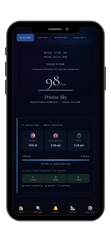
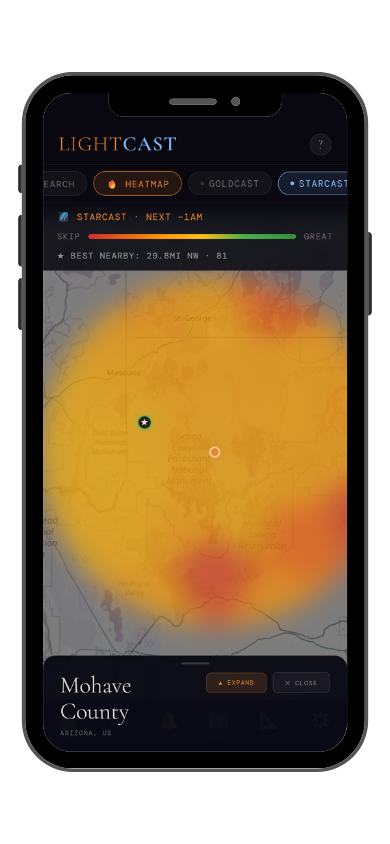
Night sky score · moon · transparency · seeing
Cloud Cover · Moon Phase · Atmospheric Transparency · Seeing
StarCast scores cloud cover, moon phase, atmospheric transparency, and astronomical seeing into a single verdict — updated daily for any location. See on a map where skies are clearest before committing to the drive.
Get LightCast on iPhone
$2.99/mo · 7-day free trial
Check StarCast on web →
StarCast: night sky score (left) · conditions heatmap (right)
🚁 Drone Photography · Illinois
Best Drone Locations
Illinois's airspace is heavily managed around Chicago — O'Hare and Midway's controlled airspace covers a wide radius, and the Chicago Class B extends well into the suburbs. Outside the metro, the state opens up considerably, but always verify FAA LAANC authorization before launching. Wind is the primary operational hazard on the Illinois prairie — the flat terrain offers nothing to break afternoon gusts, and conditions can change fast. Morning launches before 9am are consistently calmer. State parks vary on drone policy; confirm with the specific site before going out. Dronecast gives you hourly wind and gust forecasts so you're not guessing.
🌊
Illinois River Valley, Starved Rock State Park LaSalle County · North-Central Illinois
The Illinois River canyon system at Starved Rock is the most dramatic aerial subject in northern Illinois — sandstone canyons carved by glacial meltwater, forested bluffs dropping to the river, and 18 distinct canyon formations visible from above. The river bends and oxbows in this stretch read beautifully from altitude in fall when the canopy turns. Drone use is restricted within Starved Rock State Park itself; the Illinois River corridor north and south of the park boundary on public land offers good vantage lines on the bluff system without the restriction. Morning launches before the river tour boats go out give clean water.
🌾
Central Illinois Prairie — Farmland Geometry McLean / Champaign Counties
Central Illinois's agricultural grid is a legitimate aerial photography subject — the abstract patchwork of field crops, drainage ditches, and section-line roads photographed from 200–400 feet produces images that read as pure geometry. The light at golden hour turns the fields amber and the long shadows of grain elevators and tree rows create strong directional lines. Choose locations well clear of the university tower clusters around Champaign-Urbana and confirm you're outside any temporary flight restriction. Low wind mornings in June (green corn) and October (harvest) are the peak windows.
Dronecast
Wind, gusts, visibility & flight score
Wind Speed · Gusts · Visibility · Cloud Base
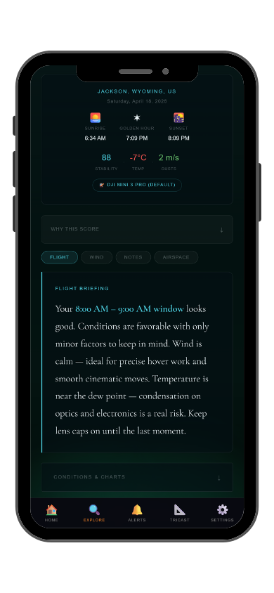
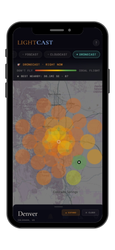
Dronecast scores wind speed, gusts, visibility, and cloud base into a single flight verdict — updated hourly. See window-by-window when conditions are safe and stable for your launch.
Get LightCast on iPhone
$2.99/mo · 7-day free trial
Check Dronecast on web →
Dronecast: flight score (left) · conditions heatmap (right)
LightCast · All tools
5 Forecasts in 1 App
🌫️
Fog Cast
Coastal fog, hour by hour
See when fog is expected to roll in or clear — so a murky morning doesn't end your golden hour session before it starts.
☁️
Cloud Cast
Cloud cover that matters to photographers
Not just "cloudy or clear" — see cloud type and coverage so you know whether you're getting dramatic texture or a blown-out white sky.
✦ Fog Cast and Cloud Cast are app-exclusive features
Frequently asked
Where is the best place to photograph sunset in Illinois?
Garden of the Gods in Shawnee National Forest offers Illinois's most dramatic sunset — sandstone formations lit amber by evening light above a forested canopy. For an urban alternative, the Chicago skyline from Montrose Beach at golden hour is one of the Midwest's signature shots. Check
GoldCast for cloud cover before you head out.
Can you see the Milky Way in Illinois?
Yes, from the southern part of the state. The Shawnee National Forest area around Devil's Backbone and Cedar Lake offers Illinois's darkest accessible skies, well clear of the Chicago and St. Louis metro light domes. You need a new moon window and a high transparency night — check
StarCast for conditions before making the drive south.
Where can I fly a drone in Illinois?
Outside the Chicago metro, much of Illinois is accessible for drone flight with FAA LAANC authorization. Starved Rock State Park restricts drones within park boundaries, but the Illinois River corridor nearby offers similar aerial subjects. Central Illinois farmland is largely unobstructed. Always check FAA B4UFLY and confirm state park policies before launching.
When is the best time to photograph fall foliage in Illinois?
Peak color in the Shawnee Hills typically arrives in mid-to-late October. The Illinois River bluffs at Starved Rock follow closely behind. Northern Illinois and the Chicago area usually see peak color in the first two weeks of October. GoldCast's cloud cover forecast helps you pick the right day when color and light align.
What is LightCast?
LightCast is a suite of sky and weather tools built specifically for photographers.
GoldCast handles sunset and sunrise timing with cloud and fog forecasts.
StarCast scores night sky conditions for astrophotography.
Dronecast gives wind and visibility forecasts for drone pilots. All three are free on web; full features are available in the
LightCast iOS app — $2.99/month after a 7-day free trial.