 Rio de Janeiro, Brazil
Rio de Janeiro
Photography Conditions
Sunset · Astrophotography · Drone Flight · Pre-loaded for Rio
The most celebrated sunset viewpoint in Rio. The rocky promontory between the two famous beaches gives an unobstructed western Atlantic horizon with Sugarloaf Mountain visible to the north. Locals gather nightly and applaud when the sun touches the water — plan to be on the rock 30 minutes before sunset to find your position. After rain the ocean water clarity and color saturation are exceptional.
Check tonight's sunset →Two cable car stages reach the summit at 396 m. The views are 360°: Guanabara Bay to the east, the Atlantic to the south, Christ the Redeemer on Corcovado to the west, and the full Rio coastline to the north. Sunset from the upper cable car platform is one of South America's great photography positions. Arrive for the last cable car of the day for the most dramatic light — check operating hours in advance.
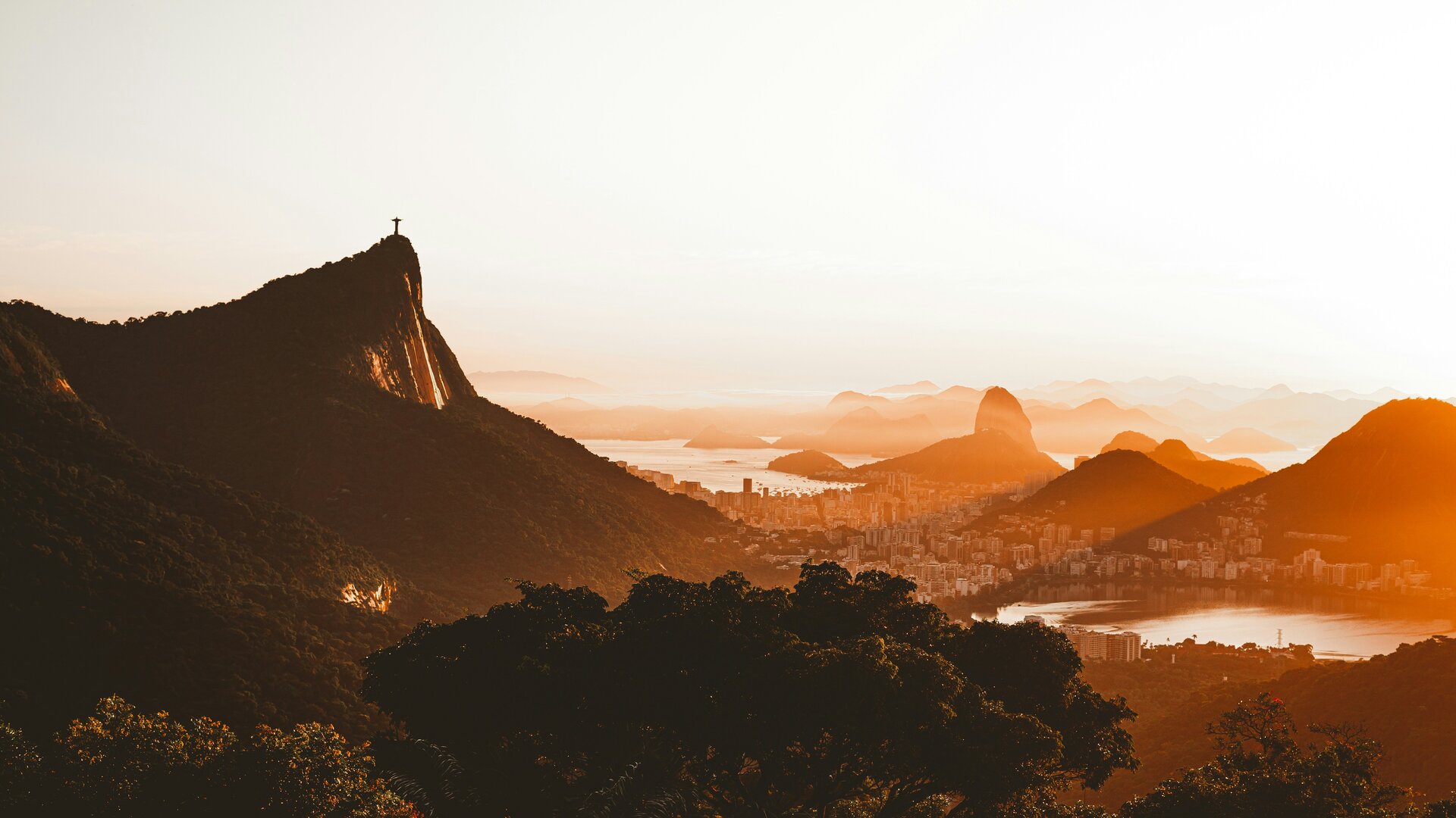
Check summit forecast →The best single composition in Rio: Christ the Redeemer on Corcovado directly above you, Sugarloaf in the frame across the bay, and the full city spread below. At sunrise the first light hits Christ from behind you (shooting east). At sunset Christ is silhouetted against the western sky. The mirante is accessible by road and is a popular but manageable viewpoint. Arrive 20 minutes early to stake a clear sightline.
Check Mirante forecast →The dramatic granite mountain range 70 km north of Rio. The national park offers Bortle 4–5 skies with the Dedo de Deus (God's Finger) peak and other spires as foreground. The Milky Way core rises in the north (southern hemisphere) October through April — shoot north toward the galactic center with mountain silhouettes below. The altitude (900–1,100 m) reduces humidity and improves transparency compared to the coast.
Check Serra dos Órgãos tonight →| Location | Distance | Bortle | Best for | |
|---|---|---|---|---|
| Serra dos Órgãos (Teresópolis) | 70 km north | 4–5 | Granite peak foreground, Atlantic forest | Starcast → |
| Parque Estadual da Serra da Bocaina | 180 km southwest | 3–4 | Escarpment views, open southern horizon | Starcast → |
| Campos do Jordão (São Paulo highlands) | 230 km southwest | 3 | High-altitude plateau, cooler and drier air | Starcast → |
| Chapada Diamantina (Bahia) | 1,100 km north | 2 | World-class dark sky, table mountain formations | Starcast → |
- Lower humidity, fewer afternoon storms, and the clearest Atlantic light of the year
- June and July are cool (20–24°C) and consistently clear — Goldcast scores peak in this window
- Milky Way core is below the horizon May through September — focus shifts fully to golden hour
- Sunrise from Arpoador on clear June mornings: ocean mist, pink sky, and no crowds before 7 AM
- October and November: Milky Way core rises in the north again after the winter absence
- Serra dos Órgãos trips are best in October before wet season humidity reduces transparency
- Tropical flora peaks in October with vivid greens and wildflowers in Tijuca Forest
- Afternoon cloud starts building from October — check Goldcast before heading to Sugarloaf
- Milky Way core is high in the northern sky January–February — but wet season limits clear nights
- Afternoon storms are daily in January and February: mornings are often clear, evenings unpredictable
- Post-storm clarity produces vivid golden hour conditions — check Goldcast after afternoon rain clears
- Carnival (February/March): streets and beaches are at peak energy but photography logistics are challenging
- March and April: wet season winding down, Milky Way still visible, humidity dropping week by week
- April is often Rio's best all-round month: warm, relatively clear, and not yet cool enough to deter beach crowds
- Tijuca Forest trails have excellent light filtering through the canopy in autumn mornings
- May marks the reliable start of dry season — plan any multi-day photography trip from May onward